Trail Creek Area Mine Claims: Idaho Springs, Colorado
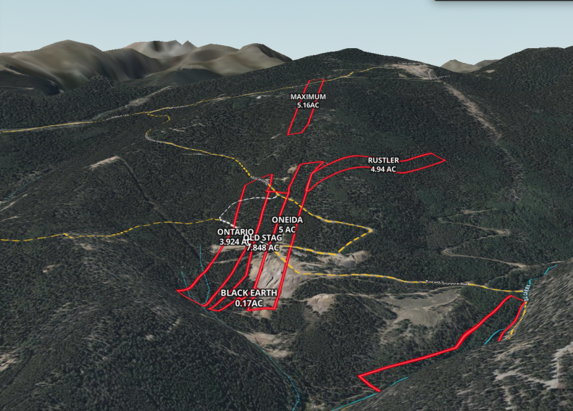
The Trail Creek Area Mining Claims just outside the Rocky Mountain Gateway town of Idaho Springs, Colorado are a collection of 7 individual claims totaling 32.042 acres; with two single parcel offerings (5 ac & 5.16 ac) and the remaining 5 contiguous claims offered together at 21.882 acres

For 3 generations the ownership family has enjoyed these lands as a place to retreat, camp and recreate; from the lovely trickling stream of Trail Creek upon the “Rustler MS” parcel to the expansive rocky mountain views offered from the middle clustered parcels and the high vantage point of the “Maximum” parcel.

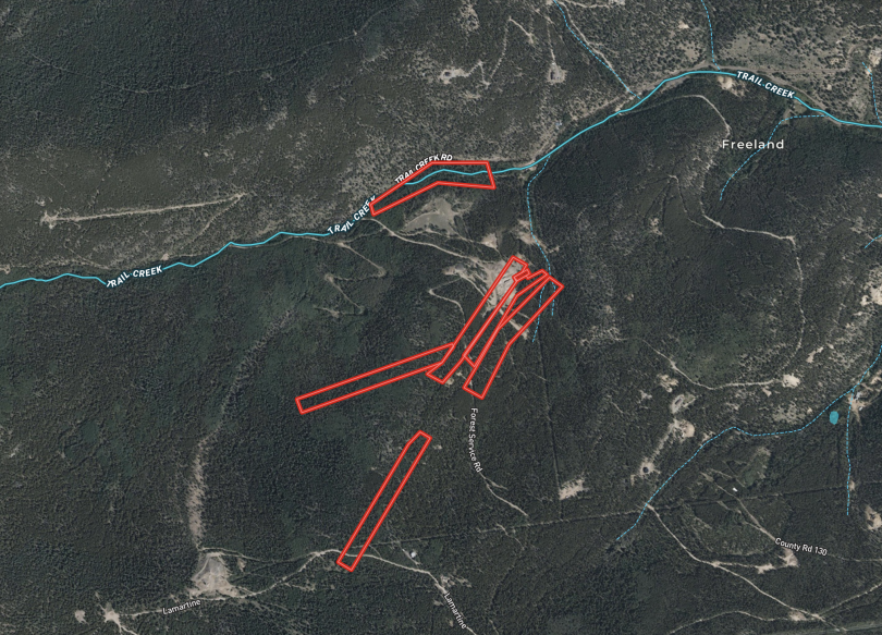
With the lower parcel located within 1/2 mile of the county maintained secondary roadway of Trail Creek Rd (road base), the parcels are then interconnected via a web of forest/county 4WD roads and tracks. A 4X4 enthusiasts dream; the network connects through to a myriad of rural mountain destinations including the old Lamartine townsite, Chicago, Ute & Cascade Creeks, Woodchuck Peak, Griffith Mountain, and the Saxon Mountain Road leading to Georgetown

“Maximum”
The 5.16 acre “Maximum” parcel (MLS# 6621345) lies mostly below Lamertine Road nearly a mile from where it begins off of Spring Creek Road. It is a narrow strip of land like so many of the mine claims historically are; with the upper region near the road setting at around 10,500 feet in elevation and boasting expansive views of the vast mountain and peak landscapes in the distance.

There are currently no know structural improvements upon the parcel, but several homes/cabins have been built along the route to the property giving a window in to the possibilities and potential of future development upon the site.


“Maximum” Parcel Offered At $72,240
“Oneida”, “Old Stag”, “Ontario”, “Black Earth” & “Rustler” Parcels
These 5 clustered and contiguous parcels (MLS# 9105870) totaling roughly 21.882 acres offer the opportunity to combine a larger site featuring expansive mountain views with historical elements of the rich mining past. There are no known building improvements currently upon these parcels, but they do have some evidence of previous mining activities, adits and shafts.

Access to these lands requires a short wheelbase 4X4 vehicle to approach either from Trail Creek Rd below or the Lamertine Rd from above from the Spring Gulch Rd.


All of these parcels are zoned Mining One (M-1) within Clear Creek County. Any questions regarding development upon the sites, or what could be built upon them should be referred to the appropriate departments within the County Government. Links to the zoning regulations are provided within the “Documents” section.
5 Contiguous Parcels Offered At $196,938
“Rustler MS” (THIS PARCEL HAS SOLD)
The 5 acre “Rustler MS” parcel (MLS#8233880) lies at the end of Trail Creek Road from about .3 mile to .6 mile from the end of the county maintained portion. The Creek traverses the entire length of the property with cascading falls and pools within the densely forested landscape and a 2 track path also runs the length with access from the upper west end where Trail Creek Rd transitions to a Forest Service Rd. The neighboring parcel to the south is owned by Clear Creek County providing an added layer of privacy from other landowners.

A small rustic cabin remains in place that has broken windows and a sagging door but perhaps could be refreshed in to an habitable shelter. The remains of another long collapsed cabin are a relic of past times. The sites of these buildings remain a great spot to enjoy the property